
Community action/Leeds

| Map | |
|---|---|
| Location | Leeds, United Kingdom |
| Coordinates | 53° 47' 50.71" N, 1° 32' 37.66" W |
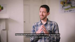
The aim of this page is to recognise, celebrate and encourage the self-empowerment of community agency networks (CANs) and community groups' activism for climate, environment and many other sustainability topics across Leeds.
News
[edit | edit source] The organisation transforming derelict homes – and how you can support it, positive.news (Sep 15, 2023)
- How refugees leading city walking tours helps increase their sense of belonging – new research, The Conversation (Jun 16, 2022)
- West Yorkshire moor brought under community ownership, thenews.coop (Oct 30, 2025) — Bridestones Moor, near Todmorden, will be managed by a CIC led by local ecologists, naturalists and residents
- Campaign launched to buy waterfall beauty spot, BBC News (Jul 17, 2025) — Campaigners say the community is ready to take responsibility for the future of the ancient woodland and waterfall
- Yorkshire enters drought after driest spring in 132 years, theguardian.com (Jun 12, 2025)
- May and June heatwaves killed about 2,700 people in England and Wales, data suggests, theguardian.com (Jul 13, 2026) — Extreme heat led to 440 deaths a day during June peak, say scientists, with climate crisis ramping up temperatures
- MPs call on UK government to host televised emergency briefing on climate crisis, theguardian.com (Jul 10, 2026) — As UK swelters in another heatwave, 50-minute Chris Packham film outlines threats to security, economy and health
- Homes need more renewable energy tech – here’s how to make sure retrofits avoid creating e‑waste, theconversation.com (Jul 08, 2026)
- May and June heatwaves killed about 2,700 people in England and Wales, data suggests, theguardian.com (Jul 13, 2026) — Extreme heat led to 440 deaths a day during June peak, say scientists, with climate crisis ramping up temperatures
- Amsterdam, along with other major European cities, bans public adverts for meat and fossil fuels [BBC], Daily Alternative (May 22, 2026)
- How reindeer herds, nature and Sámi culture can thrive when forests are restored across northern Europe, theconversation.com (May 15, 2026)
- As food shocks spread, citizens are showing more leadership than governments, climatechangenews.com (Jul 03, 2026) — People support efforts to protect forests and curb industrial food production, the results of the latest Global Citizens’ Assembly show – but politicians have been slow to act
- Trapped by floods and fearing death in the heat: the Australians taking legal action over the climate crisis, theguardian.com (Jun 22, 2026)
- ‘The sea took everything away’: how Nigeria’s ‘Happy City’ is disappearing beneath the waves, theguardian.com (Jun 18, 2026)
Networks and sustainability initiatives
[edit | edit source]- Leeds Arts Health and Wellbeing Network on twitter.com, added 15:29, 18 November 2021 (UTC)
- Hyde Park Source
- Low Impact Living Affordable Community, based in Bramley, West Leeds
Each week 3 different short videos from across the UK or world.
Rural sustainability UK, Community energy UK, Community action/Argyll and Bute / ...This week's featured Global videos / ... read more about Cosmolocalism
UK and international events
[edit | edit source]UK events
 Jul 1 - 14, 2026 (Wed - Tue) — Community Energy Fortnight, communityenergyengland.org
- Jul 02, 2026 (Thu) — Cycle to Work Day, cyclescheme.co.uk
- Jul 17 - Aug 9, 2026 (Fri - Sun) — Big Butterfly Count, bigbutterflycount.butterfly-conservation.org
- Jul 19 - 25, 2026 (Sun - Sat), The theme for 2026 is JOY — Community Centre Week, octopuscommunities.org.uk
- Jul 24 - Aug 2, 2026 (Fri - Sun) — Love Parks Week, Keep Britain Tidy
Global or international events
- July 2026 — Plastic Free July, plasticfreejuly.org
- Jul 04, 2026 (Sat) — International Day of Cooperatives (CoopsDay), 1st Saturday of July. The celebration aims to showcase co-operatives’ role in building ‘inclusive, resilient, and sustainable communities’, coopsday.coop
- Jul 18, 2026 (Sat) — Mandela Day, global celebration 18 July annually, to honour the life and legacy of Nelson Mandela. A call to action for individuals, communities, and organisations to take time to reflect on Mandela's values and principles and to make a positive impact in their own communities, mandeladay.com
2021-2030, UN Decade on Ecosystem Restoration, International community action events
Video
[edit | edit source]
Food activism
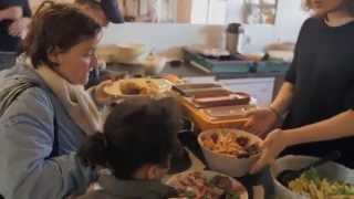
[edit | edit source]The Real Junk Food Project (TRJFP) is a British organisation that uses food that would otherwise have been discarded from supermarkets, restaurants, and other independent food suppliers to produce meals that are sold in its cafes and other food outlets. TRJFP aims to raise awareness of the huge amount of food waste in the food system. A pay what you want approach aims to make its food accessible to everyone. The project was founded by Adam Smith in Leeds in 2013.
It originally included food that had past its use-by-date, but since 2017 it has said it no longer does so in preparing meals for the public.
Community resources
[edit | edit source]Holbeck Viaduct Project
The Holbeck Viaduct Project is a community project that proposes bringing the Holbeck Viaduct in Leeds, England back into public use. The project is supported by a community group of the same name.
The Holbeck Viaduct (also known as the Farnley Viaduct) spans 92 archways and 1.1 miles (1.7 km). It runs from Leeds railway station, via Holbeck Urban Village and Old Holbeck, passes near Elland Road Stadium and ends onto wasteland in Wortley.
The viaduct was built in 1882 for the London and North Western Railway during the Industrial Revolution. It has been described as a feat of Victorian engineering, and provided a vital transport link into the booming city centre, which by the turn of the 20th century had developed into an important centre for the production of woollen cloth (See History of Leeds). The viaduct largely fell out of use in the 1960s following Leeds City Station modernisation, and the last scheduled train to pass over the viaduct did so on 11 October 1987.
A number of uses for the viaduct have been suggested, including a community garden, green walkway, arts space, park, cycle path, events hub, public allotment, café, music venue, viewing platform, local landmark or other community-focused project.
The Holbeck Viaduct Project community group envisages that the viaduct will open in 2023. The proposed timeline for the development is:
- 2016–2017: Pre-feasibility scoping report
- 2017–2018: Detailed feasibility and stakeholder engagement
- 2018–2020: Fundraising and securing land and planning
- 2021–2023: Constructing, planting and opening.
The project is happening at the same time as the South Bank Leeds regeneration, which has the aim of doubling the size of Leeds city centre.
The community group supporting the project seeks to develop the project in a highly participatory manner, drawing on the time, skills and resources of a wide range of people and organisations. The group has a website and mailing list, and is represented on Twitter and Facebook. The group is seeking new volunteers and supporters to support their community-based proposals, including detailed feasibility study to underpin future fundraising.
The project has previously been referred to as the Holbeck High Line, echoing the High Line in New York. However, the name Holbeck Viaduct Project reflects a wider range of options and a desire to create an affordable project which truly reflects Leeds and its local communities.
The Holbeck Viaduct Project is not to be confused with the nearby Monk Bridge Viaduct development, in nearby Whitehall Road, which will see a separate viaduct turned into a sky park, alongside bars, restaurants and apartments.
Health and wellbeing
[edit | edit source]- The Kindness Revolution at #KinderLeeds, added 17:31, 21 August 2020 (UTC)
Reduce, reuse, repair and recycle
[edit | edit source]- Zero Waste Leeds, "building a movement to helpmake Leeds a zero waste city by 2030", added 15:25, 7 December 2022 (UTC)
- Leeds repair cafe
Climate action
[edit | edit source]- Climate Action Leeds, added 21:13, 3 December 2021 (UTC)
- Our Future Leeds, added 21:13, 3 December 2021 (UTC)
Leeds Climate Change Citizens' Jury
Commissioned by the Leeds Climate Commission in 2019, the Citizens' Jury recruited 25 randomly selected citizens over nine sessions to answer the question 'What should Leeds do about the emergency of climate change?' An oversight panel of key stakeholders met to ensure the recruitment process was fair and robust and to agree which 'commentators' should present
evidence to the jury. The twelve strong oversight panel included representation from The City Council, the Chamber of Commerce and Extinction Rebellion. The citizens' jury commenced on 12 September 2019 and will run for a total of 30 hours over nine sessions, ending on 3 November...sharedfuturecic.org.uk, Oct 2019, p. 7
& leedsclimate.org.uk
Sustainable transport activism
[edit | edit source]Leeds is claimed by the city council to be one of the best cities in the UK for walking. The Leeds Country Way is a waymarked circular walk of 62 miles (100 km) through the rural outskirts of the city, never more than 7 miles (11 km) from City Square. The Meanwood Valley Trail leads from Woodhouse Moor along Meanwood Beck to Golden Acre Park. The Leeds extension of the Dales Way follows the Meanwood Valley Trail before it branches off to head towards Ilkley and Windermere. Leeds is on the northern section of the Trans Pennine Trail for walkers and cyclists, and the towpath of the Leeds and Liverpool Canal is another walking and cycling route. The White Rose Way walking trail to Scarborough begins at City Square. There are many parks and public footpaths in both the urban and rural parts of Leeds, and The Ramblers' Association, YHA and other walking organisations offer sociable walks. The Ramblers' Association publish booklets of walks in and around Leeds.
The Leeds and Liverpool Canal is a canal in Northern England, linking the cities of Leeds and Liverpool.
Over a distance of 127 miles (204 km), crossing the Pennines, and including 91 locks on the main line. The Leeds and Liverpool Canal has several small branches, and in the early 21st century a new link was constructed into the Liverpool docks system.
Cycling activism
[edit | edit source]- Leeds Cycling Campaign, a broad and inclusive group of people united in our desire to make Leeds a much better place for cycling. added 18:31, 31 December 2021 (UTC)
In 2010, Leeds Cyclepoint opened at Leeds railway station providing cycle hire by the day as well as paid secure parking for up to 300 cycles. The council provide maps showing ideal road routes for cyclists cycling maps. The Leeds Cycling Campaign works with the council and campaigns for improved cycling provision.
In late 2014 work started on Cycle City Connect, which includes a mostly segregated cycle path connecting Seacroft in East Leeds to Bradford, as well as resurfacing parts of the Leeds-Liverpool Canal shared use tow path. The government granted more money to Leeds, one example is £7.06 million under Transforming Cities Fund (TCF) to deliver improved and expanded cycle links and cycling routes in the city centre and beyond.
Since the 2014 Tour de France the number of publicly available bike lock-up rack has been increased, which includes high-capacity racks shaped like car outlines. Sustrans' National Cycle Network has several of its routes running through Leeds. These are the major routes 66 (between Manchester and York) and 67 (from Sheffield), as well as suburban routes 668 (from Alwoodley) and 677 (Wyke Beck Way).
An electric bicycle rental scheme, Leeds City Bikes, operated by Beryl, opened in September 2023. Users must download an app, and can pay on a one-off basis or buy a pass or a "bundle" of minutes as a regular customer. The bikes are collected from bays around the city centre, and hirers are penalised if they do not return the bike to one of the bays. The company is named after Leeds cyclist Beryl Burton. In the period from the scheme's launch until February 2024, 13,000 journeys were made totalling almost 36,000 km (22,000 mi). There were 200 bikes available from 20 bays. The number of bikes was planned to increase to 650 in spring of 2024.
- Cycling information from leeds.gov.uk
Visions
- Cycling: A Vision For Leeds, leedscyclingcampaign.co.uk, added 18:31, 31 December 2021 (UTC)
Environment quality
[edit | edit source]Resources
- School Streets: Reducing children's exposure to toxic air pollution and road danger, mumsforlungs.org, Research concerning 4 cities: London, Birmingham, Bristol and Leeds, Jan 2021
Leeds will introduce a Clean Air Zone in 2020, which will charge the most polluting buses, coaches HGVs £50 a day to enter the city, while taxis and private hire vehicles which are not clean enough will be charged £12.50 a day. The proposals came after the government ordered the council to come up with ways to lower the air pollution in the city, which causes around 29,000 premature deaths in the UK. W
Open spaces
[edit | edit source]Leeds has many large parks and open spaces. Roundhay Park is the largest park in the city and is one of the largest city parks in Europe. The park has more than 700 acres (2.8 km2) of parkland, lakes, woodland and gardens which are all owned by Leeds City Council.
Other parks in the city include: Beckett Park, Bramley Fall Park, Cross Flatts Park, East End Park, Golden Acre Park, Gotts Park, the gardens and grounds of Harewood House, Horforth Hall Park, Meanwood Park, Middleton Park, Potternewton Park, Pudsey Park, Temple Newsam, Western Flatts Park and Woodhouse Moor. There are many more smaller parks and open spaces scattered around the city, which make up around 21.7% of the city's total area. A 2017 survey ranked Leeds 7th among the ten largest UK cities (by population) for the amount of green space, although published comments on the survey pointed out major inconsistencies in the city boundaries used.
As part of the South Bank regeneration project, plans are in development for Aire Park, a new 3.5 hectare city centre park located close to the former Tetley Brewery site. Planning permission for the first phase to be undertaken by Vastint UK was granted in December 2018. In 2023, the Monk Bridge viaduct was restored by a developer and subsequently opened as the Monk Bridge Viaduct Garden.
Leeds is within a green belt region that extends into the wider surrounding counties and is in place to reduce urban sprawl, prevent the settlements in the West Yorkshire conurbation from further convergence, protect the identity of outlying communities, encourage brownfield reuse, and preserve nearby countryside. This is achieved by restricting inappropriate development within the designated areas, and imposing stricter conditions on permitted building.
Over 60% of the Leeds district is green belt land and it surrounds the settlement, preventing further sprawl towards nearby communities. Larger outlying towns and villages are exempt from the green belt area. However, smaller villages, hamlets and rural areas are 'washed over' by the designation. The green belt was first adopted in 1960, and the size in the borough in 2017 amounted to some 33,970 hectares (339.7 km2; 131.2 sq mi). A subsidiary aim of the green belt is to encourage recreation and leisure interests, with rural landscape features, greenfield areas and facilities including Temple Newsam Park and House with golf course, Rothwell Country Park, Middleton Park, Kirkstall Abbey ruins and surrounding park, Bedquilts recreation grounds, Waterloo lake, Roundhay castle and park, and Morwick, Cobble and Elmete Halls.
Trees, woodland and forest
[edit | edit source]The Forest of Leeds was originally the Forest of Loidis in which today's city of Leeds arose. It now refers to patches of woodland throughout the metropolitan district, managed by Leeds City Council amounting to 1200 hectares. These are in 55 units of various kinds of woodlands, including those of Belle Isle, Gledhow, Golden Acre Park, Lotherton Hall, Meanwood Valley, Middleton Park, Moortown, Roundhay Park, Temple Newsam and Woodhouse Ridge, formed as a forest in 1993.
News archive
[edit | edit source]2014-2016
- Soil and soul: 'Leeds is the perfect combination of rural and urban', Oct 28, 2016...The Guardian
- How to create happy communities through co-housing, November 21, 2014...The Guardian
- Leeds city council's radical step to give more power to the people, June 30, 2014...theguardian.com
About Leeds
[edit | edit source]Campaigns
Past events
- Oct 10 - 16, 2021 Leeds Festival Of Kindness, Compassion & Wellbeing The Kindness Revolution at #KinderLeeds
Leeds is a city in West Yorkshire, England. It is the largest settlement in Yorkshire and the administrative centre of the City of Leeds Metropolitan Borough, which is the second most populous district in the United Kingdom. It is built around the River Aire and is in the eastern foothills of the Pennines. The city was a small manorial borough in the 13th century and a market town in the 16th century. Leeds expanded in the 17th and 18th centuries by becoming a major production and trading centre (mainly with wool). It was awarded a city charter in 1893 by Queen Victoria.
| Authors | Phil Green |
|---|---|
| License | CC-BY-SA-3.0 |
| Cite as | Philralph (2021–2025). "Community action/Leeds". Appropedia. Retrieved July 13, 2026. |