
Community action/Madrid

The aim of this page is to recognise, celebrate and encourage the self-empowerment of community agency networks (CANs) and community groups' activism for climate, environment and many other sustainability topics across Madrid.
News
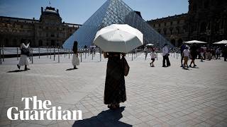
[edit | edit source] Madrid’s summers can be brutally hot. So why are so many of our trees being chopped down? Felicity Hughes, theguardian.com (Aug 15, 2024)
 - The eye-popping new school designed by its pupils, Positive News (Apr 12, 2023)
- Europe needs affordable, low‑carbon homes – here’s how Barcelona is reimagining its housing system, theconversation.com (Apr 08, 2026)
- A housing commons for the Basque country - starting with bicycles and cars!, growingcommons.substack.com (Mar 29, 2026)
- Spain to open network of climate shelters, BBC News (Dec 17, 2025)
- Amsterdam, along with other major European cities, bans public adverts for meat and fossil fuels [BBC], Daily Alternative (May 22, 2026)
- How reindeer herds, nature and Sámi culture can thrive when forests are restored across northern Europe, theconversation.com (May 15, 2026)
- Rewilding giants: captive elephants rehomed in Europe’s first sanctuary, theguardian.com (May 07, 2026)
- Trapped by floods and fearing death in the heat: the Australians taking legal action over the climate crisis, theguardian.com (Jun 22, 2026)
- ‘The sea took everything away’: how Nigeria’s ‘Happy City’ is disappearing beneath the waves, theguardian.com (Jun 18, 2026)
- Trash and dignity: The rise of inclusive recycling projects in Latin America, globalvoices.org (Jun 12, 2026)
International events
[edit | edit source]Global or International events
 July 2026 — Plastic Free July, plasticfreejuly.org
- Jul 04, 2026 (Sat) — International Day of Cooperatives (CoopsDay), 1st Saturday of July. The celebration aims to showcase co-operatives’ role in building ‘inclusive, resilient, and sustainable communities’, coopsday.coop
- Jul 18, 2026 (Sat) — Mandela Day, global celebration 18 July annually, to honour the life and legacy of Nelson Mandela. A call to action for individuals, communities, and organisations to take time to reflect on Mandela's values and principles and to make a positive impact in their own communities, mandeladay.com
2021-2030, UN Decade on Ecosystem Restoration, International community action events
Each week 3 different short videos from across the world.

Citizens' assembly, Community action/Europe, Localism / ...This week's featured UK videos / ... read more about Cosmolocalism
Madrid video
[edit | edit source]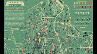

Networks and sustainability initiatives
[edit | edit source]- Neighbourhood initiatives across Madrid
- Los Madriles, Atlas de iniciativas vecinales (Atlas of neighbourhood initiatives), "What you have in front of you is an unfinished atlas of Madrid and its neighbourhood initiatives that have created new spaces of possibility, through self-management and participation. It also wants to be a gesture of recognition, gratitude, visibility, self-criticism and inclusion." latest news item Jan 2019, content available under a creative commons license
- Centro de Resiliencia de Aranjuez, closed 2017, content available under a creative commons license
Community involvement
[edit | edit source]Food activism
[edit | edit source]- Network of Urban Gardens of Madrid, The creation of the Network arose to make urban agriculture in Madrid visible, to respond to the needs of urban gardens to receive mutual support and share knowledge, experiences, inputs, etc.
- One of the objectives of the network is to create a meeting point between community agroecology initiatives in our city and move towards a friendlier city model that is interested in issues such as environmental education, food sovereignty, open distribution channels of products, consumer groups, sustainable mobility, agrocomposting, etc. content available under a creative commons license
Community resources
[edit | edit source]- Community Lovers Guide, Madrid
- El Campo de Cebada, Madrid, 2010; on facebook
Cycling
[edit | edit source]BiciMAD is a bicycle sharing system in Madrid, Spain. It is currently provided by the Empresa Municipal de Transportes de Madrid, a public company owned by the City Council of Madrid.
The service, originally granted to Bonopark SL, began operations on 23 June 2014. It was municipalized by the City Council on 17 May 2016. BiciMAD reached the number of 16,000 daily transportations for the first time in September 2018. As of March 2021, the system comprises 2964 bikes and 264 stations.
- bicimad.com
- by bike in Madrid, (blog)
Environment quality
[edit | edit source]The mandate of left-wing Mayor Manuela Carmena (2015–2019) delivered the renaturalization of the course of the Manzanares across the city. W
Open spaces
[edit | edit source]Madrid has the second highest number of aligned trees in the world, with 248,000 units, only exceeded by Tokyo. Madrid's citizens have access to a green area within a 15-minute walk. Since 1997, green areas have increased by 16%. At present, 8.2% of Madrid's grounds are green areas, meaning that there are 16 m2 (172 sq ft) of green area per inhabitant, far exceeding the 10 m2 (108 sq ft) per inhabitant recommended by the World Health Organization.
A great bulk of the most important parks in Madrid are related to areas originally belonging to the royal assets (including El Pardo, Soto de Viñuelas, Casa de Campo, El Buen Retiro, la Florida and the Príncipe Pío hill, and the Queen's Casino).[92] The other main source for the "green" areas are the bienes de propios [es] owned by the municipality (including the Dehesa de la Villa, the Dehesa de Arganzuela or Viveros). El Retiro is the most visited location of the city. W
Trees, woodland and forest
[edit | edit source]Across the Manzanares, lies the Casa de Campo, a large forested area with more than 1700 hectares (6.6 sq mi) where the Madrid Zoo, and the Parque de Atracciones de Madrid amusement park are located. It was ceded to the municipality following the proclamation of the Second Spanish Republic in 1931.
The Monte de El Pardo is the largest forested area in the municipality. A holm oak forest covering a surface over 16,000 hectares, it is considered the best preserved mediterranean forest in the Community of Madrid and one of the best preserved in Europe. Already mentioned in the Alfonso XI's Libro de la montería [es] from the mid-14th century, its condition as hunting location linked to the Spanish monarchy help to preserve the environmental value. During the reign of Ferdinand VII the regime of hunting prohibition for the Monte de El Pardo became one of full property and the expropriation of all possessions within its bounds was enforced, with dire consequences for the madrilenians at the time. It is designated as Special Protection Area for bird-life and it is also part of the Regional Park of the High Basin of the Manzanares.
Other large forested areas include the Soto de Viñuelas, the Dehesa de Valdelatas [es] and the Dehesa de la Villa [es]. As of 2015, the most recent big park in the municipality is the Valdebebas Park. Covering a total area of 4.7 km2 (1.8 sq mi), it is sub-divided in a 3.4 km2 (1.3 sq mi) forest park (the Parque forestal de Valdebebas-Felipe VI [es]), a 0.8 km2 (0.31 sq mi) periurban park as well as municipal garden centres and compost plants. W
News archive
[edit | edit source]- In 2018, Madrid Is the City to Watch for Environmental Progress, Jan 3, 2018...citylab.com
Madrid as a democracy lab, Jul 10, 2017...opendemocracy.net
- How Madrid's residents are using open-source urban planning to create shared spaces – and build democracy, Jun 27, 2017...theconversation.com
- Madrid's mayor is determined to clean up its air – by pedestrianising its biggest shopping street, Jan 16, 2017...citymetric.com
Madrid Is Giving Itself a Car Ban For Christmas, Dec 5, 2016...citylab.com
- Madrid is covering itself in plants to help fight rising temperatures, February 3, 2016...fastcoexist.com
- Madrid first city in the world to apply sustainability criteria to parking, August 6, 2014...European Green Capital
- The Madrid P2P Commune, May 22, 2014...Guerrilla Translation!
- Madrid's Big Plan to Swear Off Cars, December 4, 2013...The Atlantic Cities
About Madrid
[edit | edit source]Madrid is the capital and most populous city of Spain. It had a population of over 3.4 million in the city proper in 2025, and a metropolitan area population of approximately 6.8 million. Madrid is the second-largest city in the European Union (EU), after Berlin, and its metropolitan area is the second-largest in the EU, after Paris. The municipality covers an area of 605.77 square kilometres (233.89 sq mi). Madrid lies on the River Manzanares in the central part of the Iberian Peninsula at about 660 metres (2,170 ft) above mean sea level. The capital city of both Spain and the surrounding autonomous community of Madrid, it is the political, economic and cultural centre of the country.
The primitive core of Madrid, a walled military outpost, dates back to the late 9th century, under the Emirate of Córdoba. Conquered by Christians in 1083 or 1085, it consolidated in the Late Middle Ages as a sizeable town of the Crown of Castile. The development of Madrid as an administrative centre was fostered after 1561, as it became the permanent seat of the court of the Hispanic Monarchy. The following centuries were characterised by the reinforcement of Madrid's status within the framework of a centralised form of state-building.
See also
[edit | edit source]- Topic overview: Networks, Community involvement, Food activism, Community resources, Cycling activism, Environment quality activism, Open spaces activism, Trees, woodland and forest
| Authors | Phil Green |
|---|---|
| License | CC-BY-SA-3.0 |
| Cite as | Philralph (2022–2025). "Community action/Madrid". Appropedia. Retrieved July 11, 2026. |