
Community action/Gravesham

The aim of this page is to recognise, celebrate and encourage the self-empowerment of community agency networks (CANs) and community groups' activism for climate, environment and many other sustainability topics across Gravesham.
News
[edit | edit source] Hedgerows the 'unsung heroes of the countryside', BBC News (Feb 16, 2026) — A group of Kent volunteers is aiming to provide vital habitat for wildlife by planting about 3,800 yards (3,500m) of hedgerows in the countryside this year.
- ‘To live a normal life again, it’s a dream come true’: UK’s first climate evacuees can cast off their homes and trauma, theguardian.com (Feb 09, 2026)
- Behind the scenes as GPs face 'tidal wave of demand', BBC News (Jan 22, 2026)
- May and June heatwaves killed about 2,700 people in England and Wales, data suggests, theguardian.com (Jul 13, 2026) — Extreme heat led to 440 deaths a day during June peak, say scientists, with climate crisis ramping up temperatures
- MPs call on UK government to host televised emergency briefing on climate crisis, theguardian.com (Jul 10, 2026) — As UK swelters in another heatwave, 50-minute Chris Packham film outlines threats to security, economy and health
- Homes need more renewable energy tech – here’s how to make sure retrofits avoid creating e‑waste, theconversation.com (Jul 08, 2026)
- May and June heatwaves killed about 2,700 people in England and Wales, data suggests, theguardian.com (Jul 13, 2026) — Extreme heat led to 440 deaths a day during June peak, say scientists, with climate crisis ramping up temperatures
- Amsterdam, along with other major European cities, bans public adverts for meat and fossil fuels [BBC], Daily Alternative (May 22, 2026)
- How reindeer herds, nature and Sámi culture can thrive when forests are restored across northern Europe, theconversation.com (May 15, 2026)
- As food shocks spread, citizens are showing more leadership than governments, climatechangenews.com (Jul 03, 2026) — People support efforts to protect forests and curb industrial food production, the results of the latest Global Citizens’ Assembly show – but politicians have been slow to act
- Trapped by floods and fearing death in the heat: the Australians taking legal action over the climate crisis, theguardian.com (Jun 22, 2026)
- ‘The sea took everything away’: how Nigeria’s ‘Happy City’ is disappearing beneath the waves, theguardian.com (Jun 18, 2026)
Video
[edit | edit source]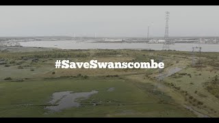
Visions
[edit | edit source]- Vision for Swanscombe Peninsula: The Save Swanscombe Peninsula SSSI community group gathered local opinions to find out what people want to see at Swanscombe Peninsula. cdn.buglife.org.uk, November 2022
Sustainable transport
[edit | edit source]The Saxon Shore Way, a long distance footpath, starts at Gravesend and traces the coast as in Roman times as far as Hastings, East Sussex; 163 miles (262 km) in total. The Wealdway also starts at the Town Pier, and continues almost due south over the Weald to Eastbourne in East Sussex where it links with South Downs Way, a distance of 80 miles (128 km).
Cycling
[edit | edit source]To the south of Gravesend on the ancient site of Watling Street on 43ha of land adjacent to the A2, Cyclopark, a venue for cycling events and other activities has been developed. The site which features mountain bike trails, a road circuit, a BMX racetrack and family cycling paths was formally opened in early 2012.
Open spaces
[edit | edit source]Windmill Hill is one of Graveshams 24 conservation areas. The 'Windmill Hill Association' looks after matters related to the area and holds regular meetings to discuss local issues. W
Shorne Woods Country Park is located between Strood and Gravesend, in the English county of Kent. It was once part of a large estate, later passed to the county council to be used as a country park.
It has large areas of ancient woodland and heathland meadows. The former claypit is being returned to nature (with woodland and wetland areas).The wetland ponds have many species of dragonflies, which breed in the park. A large part of the park is a Site of Special Scientific Interest (SSSI) with the designation Shorne and Ashenbank Woods.
The park also is accredited with a Green Flag Award by Natural England.
The country park has many colour-coded waymarked paths around the country park. These include; Purple Route - Easy 1.4 km, Red Route - Medium, Explorer Trail - 3.7 miles (6.0 km), Heritage Trail - 2.2 miles (3.5 km). A longer trail (the Darmley Trail - 6.2 miles (10.0 km)) has also been developed taking area outside of Shorne Woods park, including Darnley Mausoleum, Jeskyns (a one-time farm of 360 acres (150 ha), which is being turned into a greenspace area and country park by the Forestry Commission ), Ranscombe Farm and Cobham Hall. There is also a horse riding and cycle path route around the park. As well as a Sensory Garden for the less abled. Disabled visitors can also use 4*4 electro-scooters (called a Tramper), which can be hired from the visitor centre.
The park also has an eco-friendly visitor centre designed by Lee Evans Partnership and costing £1.6m. It was runner up in 2007 Kent Design Awards. It was the first structure to be constructed using Sweet chestnut in the UK. The mainly sweetchestnut structure, also used Oak thinnings were used from Park Wood, Kent near Appledore, as the window and roof joinery.
It is mostly powered by a wind turbine. The centre has a shop, display boards and cafe.
To the east of the park, are the Furzey Leas Lakes. Steps Lake is 0.5 acres (2,000 m2), and Long Lake is 0.65 acres (2,600 m2) These are used as angler permitted lakes, on Day Tickets (obtained from the visitor centre).
Since 2006, the park has had a Community Archaeologist as funded by the Heritage Lottery. Finds from the Stone Age (flint tools) to World War II items have been found. Most work has been taken place around the remains of Randall Manor. This was the home of Sir Henry de Cobham who lived there in 1360 to 1400. The house would have been similar to Ightham Mote but without a moat. The excavations show that it was a substantial timber-framed hall house with a stone built end. It had a garderobe and a separate kitchen making it a high status building. It had outbuildings and three fishponds. It was demolished in 1500 and the building materials re-used in the nearby Cobham Hall, now a girls' school.
More details of what was found in the park can be seen at the Kent County Council website.One of the '100 Walks in Kent' Book starts in the country park, before heading towards Owletts (a National Trust House), Cobham and Cobham Hall and then returning to the park.
Shorne Woods Country park is also home to a parkrun which is a free timed 5k event fully staffed by volunteers. The first Shorne Woods parkrun took place on 30 March 2013.
News archive
[edit | edit source]2020- 2022
- London Resort plans officially withdrawn, with the intention of resubmitting them later in the year, Wikipedia (Mar 29, 2022)
- A message to the people of Gravesham…, CPRE Kent, Dec 10, 2020...@CPREKent
- Gravesham district launches website in response to Green Belt threat, CPRE Kent, Nov 30, 2020...@protectkent
- Gravesham residents form group to fight council's housing proposals, CPRE Kent...@protectkent, Feb 10, 2020.
About Gravesham
[edit | edit source]Campaigns
- Save Swanscombe Peninsula, added 17:33, 2 February 2022 (UTC)
- Save Swanscombe Marshes, buglife.org.uk, added 09:05, 24 December 2021 (UTC) - London Resort – a fact check buglife.org.uk, added 15:42, 24 September 2021 (UTC)
- Stop the Greenbelt Grab in Gravesham, added 16:30, 11 December 2020 (UTC)
Gravesham ( GRAYV-shəm) is a local government district with borough status in north-west Kent, England. The council is based in its largest town of Gravesend. The borough is indirectly named after Gravesend, using the form of the town's name as it appeared in the Domesday Book of 1086. The district also contains Northfleet and a number of villages and surrounding rural areas.
Parts of the borough lie within the Kent Downs, a designated Area of Outstanding Natural Beauty. The neighbouring districts are Dartford, Sevenoaks, Tonbridge and Malling, and Medway, plus Thurrock on the opposite side of the River Thames.
Gravesham is twinned with Cambrai in Hauts-de-France, France and Neumünster in Schleswig-Holstein, Germany. The Gravesham parliamentary constituency covers the same area as the borough.
Near you
[edit | edit source]Dartford - Malling - Medway - Sevenoaks
See also
[edit | edit source]- Towards a more democratic and climate friendly way of meeting housing need across England
- London and South East England
- Saving water in South East England
| Authors | Phil Green |
|---|---|
| License | CC-BY-SA-3.0 |
| Cite as | "Community action/Gravesham". Appropedia. 2022–2026. Retrieved July 15, 2026. |