
Community action/Hertfordshire

| Map | |
|---|---|
| Location | Hertfordshire, East of England |
| Coordinates | 51° 52' 45.99" N, 0° 3' 49.08" W |
The aim of this page is to recognise, celebrate and encourage the self-empowerment of community agency networks (CANs) and community groups' activism for climate, environment and many other sustainability topics across Hertfordshire.
News
[edit | edit source] How community projects are building a brighter future for British farms, wickedleeks.riverford.co.uk (Nov 11, 2025)
 - How Watford got all its homeless people off the streets, BBC News (Dec 23, 2022)
Video
[edit | edit source]


Networks and sustainability initiatives
[edit | edit source]- Sustainable St Albans, Building environmental sustainability – across St Albans, Harpenden and the villages added 18:01, 25 April 2020 (UTC)
- Dacorum Environmental Forum
- Transition Hertford
- Transition in Kings Langley
- Northaw Transition
- Transition Town Berkhamsted
- Transition Town Letchworth
- Tring in Transition
Social inclusion
[edit | edit source]- Local Social CIC, connecting real lives, added 17:11, 2 June 2021 (UTC)
Food activism
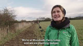
[edit | edit source]Woodoaks Farm, Growing Together, added 16:46, 9 March 2022 (UTC)
Maps
Honey Map, Herts Bees
Sustainable transport activism
[edit | edit source]Walking:
- The Ridgeway
- Icknield Way
- Grand Union Canal Walk
- Harcamlow Way
- Hertfordshire Way
- Hertfordshire Chain Walk
Waterways: Wikipedia: Canals in Hertfordshire (category)
Trees, woodland and forest
[edit | edit source]- Woodoaks Farm, Growing Together, added 16:46, 9 March 2022 (UTC)
Watling Chase Community Forest
Watling Chase Community Forest is an area of 72 square miles located in north London and south Hertfordshire around the towns of Potters Bar, Radlett, Borehamwood and Barnet. It includes Aldenham Country Park, Scratchwood, Moat Mount Open Space and the Watling Chase Timberland Trail, a waymarked walk of 16 kilometres.
It was set up in 1991 and is one of twelve community forests in England set up to regenerate the countryside in and around urban areas. They are sponsored by Natural England and the Forestry Commission which work with local authorities and voluntary bodies to manage them.
News archive
[edit | edit source]2009-2016
- Second St Albans Sustainability Week proves district is keen to keep it green, Dec 2, 2016...hertsad.co.uk
- Network St Albans should be copied around the country, Campaign for Better Transport April 20, 2009.
Blogs
Green St Albans, thoughts from St Albans' first Green Councillor
About Hertfordshire
[edit | edit source]Campaigns
- Just say No! Save out green Belt in North Herts, added 14:13, 8 November 2021 (UTC)
- Stop Stansted Expansion
Past events
- Nov 25, 2016, "What can we do about air pollution in St Albans?", public meeting
- February 27, 2016, Eco Fair and Seed Swap tringintransition.org.uk
- November 21 - 28, 2015, Sustainable St Albans Week
Hertfordshire ( , HART-fərd-shər, -sheer; often abbreviated Herts) is a ceremonial county in the East of England. It borders Bedfordshire to the north-west, Cambridgeshire to the north-east, Essex to the east, Greater London to the south and Buckinghamshire to the west. The largest settlement is Watford.
The county has an area of 634 square miles (1,640 km2) and had an estimated population of 1,236,191 in 2024. Watford is in the south-west of the county, and its other settlements include Stevenage in the north, the city of St Albans in the centre, and Hemel Hempstead in the west. For local government purposes Hertfordshire is a non-metropolitan county with ten districts. Potters Bar in the south-east of the county was historically part of Middlesex.
Hertfordshire centres on the headwaters and upper valleys of the rivers Lea and the Colne; both flow south and each is accompanied by a canal. Elevations are higher in the north and west, reaching more than 800 feet (240 m) in the Chilterns near Tring. Hertfordshire's undeveloped land is mainly agricultural and much of the county is covered by the Metropolitan green belt.
Since 1903, Letchworth, in the far north, has served as the prototype garden city while Stevenage became the first town to expand under post-war Britain's New Towns Act 1946. Services have become the largest sector of the county's economy.
See also
- Towards a more democratic and climate friendly way of meeting housing need across England
- London and South East England
| Authors | Phil Green |
|---|---|
| License | CC-BY-SA-3.0 |
| Cite as | Philralph (2014–2025). "Community action/Hertfordshire". Appropedia. Retrieved July 11, 2026. |