
How to measure head for microhydro with Google Earth
- Note-Inaccurate in some areas.
Calculating head from Google Earth
[edit | edit source]Head, or change in elevation, must be measured to determine potential power for a microhydro system. There are several methods used to measure head, including reading topographic maps, using a GPS device or using a level and tape measure on site. This article describes how to measure head using Google earth mapping.
- Download Google Earth, a free service here.
- Search for you potential site with the name of a nearby location or with latitude and longitude in the search bar in the top left corner.
- Select the path button from the tool bar at the top of the screen (see figure 1).
- Draw a path roughly from the point of take-off to the location of the turbine (see figure 2).
- Name the path and select measurements to determine length of the path, you will need this to determine head loss due to friction later (see figure 3).
- Click ok to save the path and then click edit from the tool bar and choose show elevation profile
- The head is the initial elevation minus the final elevation. Don't worry about what happens in between these two elevations because head is a measure of change in elevation between two points. (see figure 4).
You've just calculated your change in elevation. If the change in elevation is much lower than 50 feet you may want to consider a different site.
-
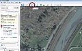 Figure 1:Path Button
 -
Figure 2:Make a path between roughly where you'd like to start and end the penstock
-
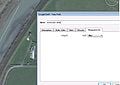 Figure 3:Measure roughly the length of the penstock
 -
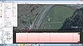 Figure 4:Calculate head from initial and final elevation. This site is probably not a good location!


| Authors | |
|---|---|
| License | CC-BY-SA-3.0 |
| Cite as | MeghanHeintz (2012–2025). "How to measure head for microhydro with Google Earth". Appropedia. Retrieved July 20, 2026. |