The principle behind runoff reduction measures is to increase the proportion of precipitation that infiltrates the soil and decrease the amount that runs off directly into rivers.
On undeveloped land, typically less than 20 percent of the volume of rainfall becomes direct surface runoff that drains into rivers.[1] With development of buildings and paved impermeable surfaces, and the use of conventional piped drainage systems, direct runoff can increase to over 80 percent of the volume of rainfall. By reducing the amount of runoff, the streamflow levels during storm events will be reduced, thereby reducing flood risk and the need for structures such as dams.
In urban areas[edit | edit source]
In urban areas, the types of techniques recommended to reduce runoff include:
- Infiltration trenches, which are rock-filled trenches in which stormwater is stored in the voids of the stones, and then slowly filters back into groundwater;
- Downspout diversion programs (i.e., allowing domestic gutters to discharge to lawns or other unpaved areas instead of being connected to the sewers);[2]
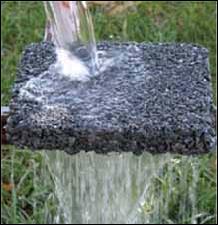
- Permeable or porous pavements for roads and parking lots;
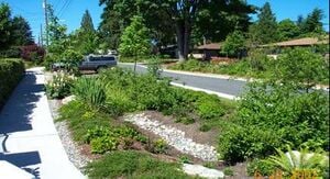
- Swales (i.e., grass depressions that catch runoff from impermeable surfaces and slowly filter it back into groundwater) or grassed surface conveyance;
- Infiltration and treatment systems which can also serve as landscape features;
- Wide filter or buffer strips of natural vegetation or inclusion of levees and dikes: grass or woodland, usually located between paved areas and the watercourse to slow flows and remove pollutants;
- Small detention basins: grassy and vegetated depressions that hold and treat excess surface water for slow release;
- Infiltration basins that hold surface water, allowing it to infiltrate the soil gradually; and retention ponds or permanently wet ponds that retain surface runoff and provide biological treatment through wetland and aquatic vegetation such as reeds.
Advantages[edit | edit source]

These strategies are considered preventative measures that reduce the fundamental flood risk by reducing runoff and peak flood flows. Many of these strategies cost relatively little money compared to dams and levees and they can be squeezed into dense urban areas because most do not require large amounts of space.
Disadvantages[edit | edit source]
One drawback to these strategies is that in order to significantly reduce runoff, these strategies must be implemented in many locations. In addition, the dispersed and incremental nature of this approach poses a challenge to quantify the impacts and maintain the effectiveness of the measures. Although many of the measures listed above require little space, large infiltration or detention basins could be difficult to site within urban areas. In addition, care must be taken to ensure that detention basins do not increase flood peaks.[3]
Costs[edit | edit source]
Costs will vary greatly depending on the measure chosen, ranging from less than $100 to install downspout diversions to hundreds of thousands of dollars for elaborate infiltration basins. The good news is that many of these techniques cost less than traditional stormwater drain systems. For an additional project cost-savings example, see the case study below.
Reducing urban runoff case study #1[edit | edit source]
In 1992, the Oregon Museum of Science and Industry (OMSI) relocated to a former industrial site on the Willamette River and in doing so decided to take steps to ensure their impact on the environment was minimal and that they addressed some of the environmental issues plaguing the watershed. In order to reduce runoff and capture stormwater on their 10-acre parking lot, OMSI chose to build 2,300 feet of bioswales rather than the traditional parking lot islands. These bioswales are linear wetlands that contain a variety of native plants and trees. While still not considered inexpensive, these bioswales did cost $70,000 less than a traditional stormwater drainage system and has resulted in little stormwater discharge during a normal storm event. OMSI also chose to protect and rebuild the banks of the Willamette from erosion by planting native riparian shrubs in the buffer. FEMA cited this project as an excellent example of the use of bioengineering, and during the floods of 1996 and 1997, the bank stabilization survived.
To learn more about the Oregon Museum of Science and Industry’s project, visit http://web.archive.org/web/20040409044529/http://www.fish.ci.portland.or.us:80/pdf/pdc1.pdf
Reducing urban runoff case study #2[edit | edit source]
As Atlanta, Georgia’s population continues to expand, the Big Creek watershed is facing increasing threats from development interests. Presently, the watershed is 16 percent impervious cover; with negative effects from stormwater runoff beginning at about ten percent impervious cover. The resulting impacts from excess runoff include degraded water quality, erosion, increased flood damage and habitat degradation, as well as the construction of dams and levees and stream channelization. A reconnaissance study was undertaken to develop recommendations to reduce the adverse impacts of urbanization on the watershed, which included stormwater management, riparian buffers and restoration. Stormwater management recommendations included the creation of stormwater ponds and natural detention and infiltration facilities that would improve water quality and capture and store runoff and floodwater. The riparian buffers and corridors will also store and extend the discharge of floodwaters, as well as decrease erosion and remove pollutants from stormwater runoff. By allowing runoff to be absorbed into the earth and undergo a more natural hydrologic process, flood impacts could be significantly reduced in the Big Creek watershed and flood management infrastructure, such as dams and levees, could be removed.[4]
To learn more about the Big Creek reconnaissance study in Atlanta, Georgia, visit http://web.archive.org/web/20050322004651/http://www.forester.net:80/sw_0011_assessing.html
Where you can go for help[edit | edit source]

- For more information, contact your state natural resources agency, such as Department of Natural Resources or Department of Environmental Protection.
- Stormwater Managers Resource Center
- American Rivers, Natural Resources Defense Council, Smart Growth America, Paving Our Way to Water Shortages: How Sprawl Aggravates the Effects of Drought: http://web.archive.org/web/20080827165646/http://www.amrivers.org./landuse/sprawldroughtreport.htm.
In agricultural areas[edit | edit source]
Where land adjacent to rivers has been developed for intensive cultivation of crops, the volume and speed of runoff usually increases, contributing to the risk of flooding downstream and the possibility of pollution by herbicides, pesticides and agricultural waste products. Possible methods for minimizing these risks include:
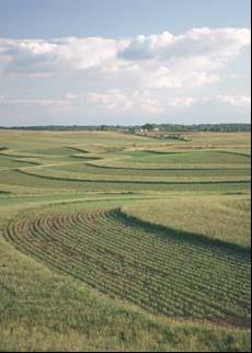
- Adopting less intensive agricultural practices (e.g., farming outfits that continually increase production each season with longer growing seasons, using a sand and clay substrate) and controling irrigation rates and contour levels so that water is retained on the land;
- Creating vegetated buffer strips or wetlands between cultivated land and watercourses to slow surface water runoff and remove pollutants; and
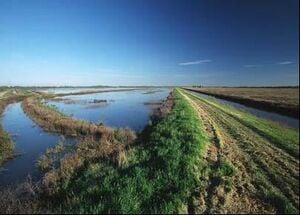
- Directing agricultural runoff to infiltration ponds, retention ponds and wetland areas to slow runoff and improve water quality. These may also provide features for wildlife.
Advantages[edit | edit source]
These measures share the same benefits of those listed for urban areas. Detention basins are usually quite shallow and require a large area to provide significant flood storage. However, because they are normally dry and will not be needed in most years, they can be put to use in the meantime. For example, the detention basins of the Lincoln, Nebraska flood alleviation scheme are farmed, and farmers receive compensation for damage to their crops when the basins are used for flood management. One option considered for the Red River watershed in Canada and the United States was that of microstorage, using the agricultural fields between the raised roads as flood storage.
Disadvantages[edit | edit source]

Implementing these measures in rural areas can present challenges similar to those in urban settings, such as the fact that these strategies may need to be implemented in many locations. If the area is composed of many smaller farms, one farmer working to reduce runoff will not impact flooding enough to lead to the removal of a dam. In addition, changing agricultural practices might be impractical for the crops under cultivation or the characteristics of the area.
Costs[edit | edit source]
The cost of runoff control measures will vary greatly depending on the size and type of measure applied. The cost of detention basins can ranges from $0.10 to $2.50 per cubic foot of detained water.[5] A relatively small detention basin that would hold the volume of a typical backyard pool, 20,000 gallons, would likely cost between $2,000 and $10,000.
Reducing agricultural runoff case study[edit | edit source]
The Lake Thompson Watershed, located in southeastern South Dakota, has lost the majority of its wetlands over the years to increase agricultural production, for which 90 percent of the land is now used. As a result of increased agricultural production and the loss of wetlands and other retention space, the region experienced severe flooding around several lakes from 1984 to 1986 that led to crop, property, and road damage. In an effort to reduce the frequency and duration of major flooding, both governmental and non-governmental organizations created a wetland restoration plan within the watershed that included restoring drained wetlands on public lands; acquiring new land to restore wetlands; developing conservation practices on private lands; and offering incentives to prevent further drainage projects. In addition to decreasing the threat of flooding, many of the restored sites once again function as wildlife habitat.[6]
To read the entire Lake Thompson case study, visit http://web.archive.org/web/20031222190121/http://ramsar.org:80/lib_wise_18.htm. For more information about this project you may also contact Tom Dahl with the U.S. Fish and Wildlife Service at 608-783-8425.
Where you can go for help[edit | edit source]
- For more information, contact your state natural resources agency, such as Department of Natural Resources or Department of Environmental Protection.
- Buffer Strips: Common Sense Conservation, USDA Natural Resource Conservation Service, http://web.archive.org/web/20110604064436/http://www.nrcs.usda.gov/feature/buffers/
- Haeuber, R. and W.K. Michener. "Natural Flood Control", Issues in Science and Technology, Fall 1998. http://web.archive.org/web/20041211172505/http://205.130.85.236:80/issues/15.1/haeube.htm.
- Buffers for Agriculture, Connecticut River Watershed: http://www.crjc.org/buffers/Buffers%20for%20Agriculture.pdf.
References[edit | edit source]
- ↑ Dunne, T. and L.B. Leopold. Water in Environmental Planning. New York: W.H. Freeman and Company, 1978.
- ↑ Downspout diversion programs have helped to maintain a consistent flow of higher water quality into urban streams. UNITED STATES studies have shown that downspout diversion programs can reduce mean flow volumes in the sanitary sewer network by 25 to 62 percent (Kaufman and Wurtz, 1997).
- ↑ For example, a detention basin in the lower area of a watershed might delay inflow to a creek such that it occurs when the flood wave is arriving from the upper watershed, thereby potentially increasing flood levels.
- ↑ Fischenich, J.C., R.B. Sotir, and T. Stanko, "Assessing Urban Watersheds: The Case of Big Creek," Stormwater: The Journal for Surface Water Quality Professionals, http://web.archive.org/web/20050322004651/http://www.forester.net:80/sw_0011_assessing.html (11 June 2002).
- ↑ Schueller, T.R. Controlling Urban Runoff: a practical manual for planning and designing urban BMPs. Metropolitan Council of Governments, 1987.
- ↑ Dahl, Thomas E., "Wetland drainage and restoration potential in the Lake Thompson watershed, South Dakota, USA," Towards the Wise Use of Wetlands, 1993, http://web.archive.org/web/20031222190121/http://ramsar.org:80/lib_wise_18.htm (11 June 2002).