
Original file (2,753 × 1,400 pixels, file size: 200 KB, MIME type: image/png)
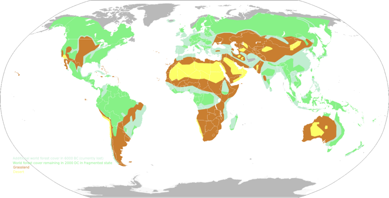
Map of the world vegetation zones/land use zones. The map was made based on http://commons.wikimedia.org/wiki/File:World_forest_cover_then_and_now.png This first map showed the (fragmented) world forests in 2000 BC, and the additional forests in 6000 BC (which have been lost since then). The schematic was made based on http://web.archive.org/web/20160303235522/http://maps.howstuffworks.com/world-forest-cover-map.htm which is itself a simplified map of World Resources Institute, Forest Frontiers Initiative, 1998 (see http://pdf.wri.org/lastfrontierforests.pdf ) The schematic was drawn from scratch with the GIMP by user:KVDP on a map from wikimedia commons An additional reference on the fragmentation and general size of the leftover forests can be found at http://www.intactforests.org/world.map.html Note that due to the Flexible Mechanisms scheme under the Kyoto protocol, it would be possible to replant the amount of forests that were present at least a few hundred years ago at an economically rewarding fashion. For this action (which btw could be accomplished in under 30 years, see http://environment.guardian.co.uk/conservation/story/0,,1947182,00.html), the map is useful as it shows the location of where forests would grow easily, and it is also useful as a rough indication as the amount of forests in 6000 BC would not have differed greatly from the amount of forests in say 1900 DC (most forests have been destroyed in the last 100-ish years) In addition to this map, deserts and grasslands were added. The deserts were drawn based on http://media.mcclatchydc.com/smedia/2008/12/19/16/466-E_World_desert.large.prod_affiliate.91.jpg (extremely arid zones) and map page 119 of Wolters Algemene Wereldatlas 1996 The latter was used to complete the missing deserts (Kizilkum, Karakum, Great Salt desert, Lut, Thar desert, Syrian-Nefud desert-Dahnd, Rub al Khali, Great erg-Sahara-Libyan desert, Namib, Great sand desert-Great Victoria desert, Simpson desert, Atacama, Mojave desert-Gila desert The grasslands were drawn based on http://www.windows2universe.org/earth/images/grassland_map_big2_jpg_image.html , http://environment.nationalgeographic.com/environment/habitats/grassland-map/ , http://www.sciencebuzz.org/blog/feeding-world-one-billion-time http://fullspectrumbiology.blogspot.com/2012/04/demise-of-conventional-agriculture.html http://web.archive.org/web/20170128184939/http://www.grida.no/graphicslib/detail/agriculture-land-use-distribution-croplands-and-pasture-land_a0ab# This map is to be used as a baseline for determining appropriate animals (animals native to the area) that allow the conversion of grass to protein.
File history
Click on a date/time to view the file as it appeared at that time.
| Date/Time | Thumbnail | Dimensions | User | Comment | |
|---|---|---|---|---|---|
| current | 08:21, 15 May 2012 | | 2,753 × 1,400 (200 KB) | KVDP (talk | contribs) | Map of the world vegetation zones/land use zones. The map was made based on http://commons.wikimedia.org/wiki/File:World_forest_cover_then_and_now.png The deserts were drawn based on http://media.mcclatchydc.com/smedia/2008/12/19/16/466-E_World_desert.lar |
You cannot overwrite this file.
File usage
The following file is a duplicate of this file (more details):
- File:World vegetation zones.png from Wikimedia Commons
The following page uses this file: