
File:MalariaSpatialDistributionMap.png
No higher resolution available.
MalariaSpatialDistributionMap.png (354 × 231 pixels, file size: 79 KB, MIME type: image/png)
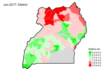
Spatial distribution of relative risk of malaria during the highest burden month of the year(wet season).
| Date created | Unknown |
|---|---|
| Author | Unknown |
| Date uploaded | December 3, 2021 |
| Uploader | Cameron |
| License | CC-BY-SA-4.0 |
File history
Click on a date/time to view the file as it appeared at that time.
| Date/Time | Thumbnail | Dimensions | User | Comment | |
|---|---|---|---|---|---|
| current | 23:44, 3 December 2021 | | 354 × 231 (79 KB) | CameronBrooks11 (talk | contribs) | Spatial distribution of relative risk of malaria during the highest burden month of the year(wet season). |
You cannot overwrite this file.
File usage
The following page uses this file: