
File:Land use map.jpg
No higher resolution available.
Land_use_map.jpg (450 × 334 pixels, file size: 29 KB, MIME type: image/jpeg)
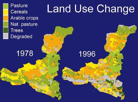
Source: UNEP/GRID-Arendal - Land Use in Cajamarca, 1978 and 1996
File history
Click on a date/time to view the file as it appeared at that time.
| Date/Time | Thumbnail | Dimensions | User | Comment | |
|---|---|---|---|---|---|
| current | 01:48, 6 May 2012 | | 450 × 334 (29 KB) | Olgamcano (talk | contribs) | Source: UNEP/GRID-Arendal - Land Use in Cajamarca, 1978 and 1996 |
You cannot overwrite this file.
File usage
The following page uses this file: