Size of this preview: 800 × 418 pixels. Other resolution: 1,000 × 522 pixels.
Original file (1,000 × 522 pixels, file size: 69 KB, MIME type: image/gif)
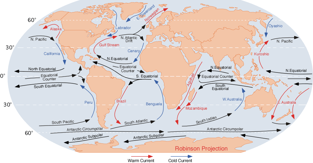
Image of the ocean currents. Note that
- E.Greenland + Labrador + Norwegian = Viking gyre
- Gulf stream + N.Atlantic Drift + Canary + N.Equatorial = Columbus gyre
- S.Equatorial + Brazil + South Atlantic + Benguela = Navigator gyre
- S.Indian + S.Equatorial + Mozambique + W. Australia = Majid gyre
- Alaska + N.Pacific + Oyashio = Aloet gyre
- Kuroshio + N. Equatorial + California = Turtle gyre
- Peru + S.Pacific + E. Australia = Heyerdahl gyre
Finally, a few gyres also exist at the poles (not shown at this map); these are:
- North pole: Polar bear gyre, Storkerson gyre, Melville gyre
- South pole: Pinguin gyre
References for the currents: Curtis Ebbesmeyer map at Wired
File history
Click on a date/time to view the file as it appeared at that time.
| Date/Time | Thumbnail | Dimensions | User | Comment | |
|---|---|---|---|---|---|
| current | 09:40, 6 June 2011 | | 1,000 × 522 (69 KB) | KVDP (talk | contribs) | Image of the ocean currents. Note that * E.Greenland + Labrador + Norwegian = Viking gyre * Gulf stream + N.Atlantic Drift + Canary + N.Equatorial = Columbus gyre * S.Equatorial + Brazil + South Atlantic + Benguela = Navigator gyre * S.Indian + S.Equato |
You cannot overwrite this file.
File usage
The following page uses this file: