The aim of this page is to recognise, celebrate and encourage the self-empowerment of community agency networks (CANs) and community groups across Bath and North East Somerset.

- Dec 23, 2019 New climate emergency network launched to link schools across B&NES[1]
Networks and sustainability initiatives[edit | edit source]
Community involvement[edit | edit source]
Bath: Hacked, joint council/community initiative bringing bright people and quality data together to do useful things for the community.
Community and voluntary action[edit | edit source]
Volunteer Centre Bath & North East Somerset
Sustainable transport activism[edit | edit source]
The city is connected to Bristol and the sea by the River Avon, navigable via locks by small boats. The Kennet and Avon Canal links it to the River Kennet at Newbury, and from there to Reading on the River Thames. W
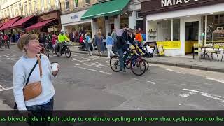
Cycling activism[edit | edit source]
Bath is on National Cycle Route 4, with one of Britain's first cycleways, the Bristol & Bath Railway Path, to the west, and an eastern route toward London on the canal towpath. W
Open spaces[edit | edit source]
The city has several public parks. W
The Avon Green Belt, also known as the Bristol and Bath Green Belt (or Bath and Bristol Green Belt), is a non-statutory green belt environmental and planning policy that regulates urban expansion and development in the countryside surrounding the cities of Bristol and Bath in the South West region of England. It covers areas in Bristol, South Gloucestershire, North Somerset, Bath and North East Somerset, Mendip, and Wiltshire. Essentially, the function of the green belt is to limit urban sprawl and maintain the open character of areas around the Bristol and Bath built up areas, and nearby towns and villages. The policy is implemented by local planning authorities on the basis of guidance from central government.
Trees, woodland and forest[edit | edit source]
- Chew Valley Plants Trees, "Co-ordinating the activity of tree planting in Chew Valley to build an ecological and social commonwealth for current and future generations", added 17:02, 16 August 2021 (UTC)
Past events[edit | edit source]
2016
Nov 3 - Bath Soup Project
2014
September 27 - 28 Bath Green Homes, community project organised by Transition Bath, Bath Preservation Trust, and Bath & North East Somerset Council.
September 14 Bath Home Improvement Fair
About Bath[edit | edit source]
Bath (RP: ; local pronunciation: [ba(ː)θ]) is a city in the ceremonial county of Somerset in England, known for and named after its Roman-built baths. At the 2021 Census, the population was 94,092. Bath is in the valley of the River Avon, 97 miles (156 km) west of London and 11 miles (18 km) southeast of Bristol. The city became a UNESCO World Heritage Site in 1987, and was later added to the transnational World Heritage Site known as the "Great Spa Towns of Europe" in 2021. Bath is also the largest city and settlement in Somerset.
Near you[edit | edit source]
See also[edit | edit source]
- Community resources Bath
- Topic overview: Networks, Community involvement, Community and voluntary action, Sustainable transport activism, Cycling activism, Open spaces activism, Trees, woodland and forest
- UK context: Networks UK, Community involvement UK, Community and voluntary action UK, Sustainable transport activism UK, Cycling activism UK, Open spaces activism UK, Trees, woodland and forest UK
References