(Added link to OTP.) |
(Normalize) |
||
| (9 intermediate revisions by 4 users not shown) | |||
| Line 1: | Line 1: | ||
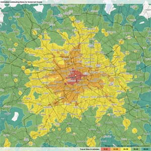
[[ | [[File:SomersetHouse60mArr3pmZoom12.jpg|thumb|Sample output from Mapumental project/tool, Public transport travel times to reach Somerset House in London by 3pm.]] | ||
"Travel Time Maps" allow understanding how far in a region an individual can reach by a certain mode of transport, from a given starting location and starting time. Their more technical name is Isochronal maps (Iso= same, chronos=time, therefore lines reachable in the same time). | "Travel Time Maps" allow understanding how far in a region an individual can reach by a certain mode of transport, from a given starting location and starting time. Their more technical name is Isochronal maps (Iso= same, chronos=time, therefore lines reachable in the same time). | ||
Travel Time Maps are proposed as useful by public transport researchers (such as on Jarett Walker's blog Human Transit) in helping people think about their transport system in terms of a geography of mobility and accessibility. | Travel Time Maps are proposed as useful by public transport researchers (such as on Jarett Walker's blog Human Transit) in helping people think about their transport system in terms of a geography of mobility and accessibility. | ||
Creating these maps using [[GIS]] platforms and relevant [[open data]] is now becoming simpler and more attainable. This includes potentially using existing [[Open source software]] tools such as [[OpenTripPlanner]]. | Creating these maps using [[GIS]] platforms and relevant [[open data]] is now becoming simpler and more attainable. This includes potentially using existing [[Open source software]] tools such as [[OpenTripPlanner]]. | ||
== See | == See also == | ||
* [[Open Source GIS-T Public Transport Tools Review]] | * [[Open Source GIS-T Public Transport Tools Review]] | ||
| Line 15: | Line 15: | ||
* http://www.humantransit.org/2012/11/the-need-for-maps-of-your-freedom.html | * http://www.humantransit.org/2012/11/the-need-for-maps-of-your-freedom.html | ||
* http://opentripplanner.com/2012/07/visualizing-urban-accessibility-with-opentripplanner-analyst | * http://web.archive.org/web/20140107094847/http://opentripplanner.com/2012/07/visualizing-urban-accessibility-with-opentripplanner-analyst/ | ||
* http://www.mapnificent.net - Free simple travel time maps for cities with a public [[GTFS]] feed integrated into Google maps | * http://www.mapnificent.net - Free simple travel time maps for cities with a public [[GTFS]] feed integrated into Google maps | ||
* http:// | * http://web.archive.org/web/20200103062826/https://mapumental.com/ - UK provider of Travel time maps service (originally free, now commercial) | ||
* http://isoscope.martinvonlupin.de/ - "Isoscope, Exploring Mobility" online project - can calculate isocrones for either car or pedestrian travel (uses the [https://developer.here.com/ HERE API] for calculations, presumably using underlying [[OpenStreetMap]] data). | |||
[[Category:Public transport]][[Category:Transport]] | {{Page data}} | ||
[[Category:Information technology]][[Category:GIS]] | |||
[[Category:Public transport]] | |||
[[Category:Transport]] | |||
[[Category:Information technology]] | |||
[[Category:GIS]] | |||
[[Category:Community informatics]] | [[Category:Community informatics]] | ||
[[Category:Transport informatics]] | [[Category:Transport informatics]] | ||
[[Category:Public transport informatics]] | |||
Latest revision as of 08:13, 3 October 2022

"Travel Time Maps" allow understanding how far in a region an individual can reach by a certain mode of transport, from a given starting location and starting time. Their more technical name is Isochronal maps (Iso= same, chronos=time, therefore lines reachable in the same time).
Travel Time Maps are proposed as useful by public transport researchers (such as on Jarett Walker's blog Human Transit) in helping people think about their transport system in terms of a geography of mobility and accessibility.
Creating these maps using GIS platforms and relevant open data is now becoming simpler and more attainable. This includes potentially using existing Open source software tools such as OpenTripPlanner.
See also[edit | edit source]
External links[edit | edit source]
- http://www.humantransit.org/2012/11/the-need-for-maps-of-your-freedom.html
- http://web.archive.org/web/20140107094847/http://opentripplanner.com/2012/07/visualizing-urban-accessibility-with-opentripplanner-analyst/
- http://www.mapnificent.net - Free simple travel time maps for cities with a public GTFS feed integrated into Google maps
- http://web.archive.org/web/20200103062826/https://mapumental.com/ - UK provider of Travel time maps service (originally free, now commercial)
- http://isoscope.martinvonlupin.de/ - "Isoscope, Exploring Mobility" online project - can calculate isocrones for either car or pedestrian travel (uses the HERE API for calculations, presumably using underlying OpenStreetMap data).