
Size of this preview: 800 × 411 pixels. Other resolution: 2,000 × 1,027 pixels.
Original file (2,000 × 1,027 pixels, file size: 402 KB, MIME type: image/png)
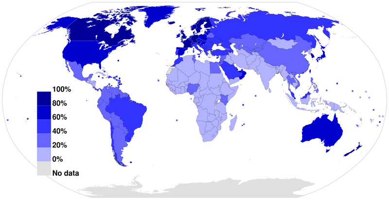
A world map colored to show the level of Internet penetration (number of Internet users as a percentage of a country's population). The image was made based on figures from the Wikipedia:List of countries by number of Internet users article in the English Wikipedia, which is in turn based on figures from the International Telecommunications Union (ITU) for 2010. URL: http://www.itu.int/ITU-D/ict/statistics/material/excel/2010/IndividualsUsingInternet_00-10.xls
The map was made by Jeff Ogden (W163)
File history
Click on a date/time to view the file as it appeared at that time.
| Date/Time | Thumbnail | Dimensions | User | Comment | |
|---|---|---|---|---|---|
| current | 09:37, 7 May 2013 | | 2,000 × 1,027 (402 KB) | KVDP (talk | contribs) | A world map colored to show the level of Internet penetration (number of Internet users as a percentage of a country's population). The image was made based on figures from the Wikipedia:List of countries by number of Internet users article in the Englis |
You cannot overwrite this file.
File usage
The following page uses this file: