
OSSTIP: an action-research effort to collaboratively build an Open Source Sustainable Transport Informatics Platform.
Project Goal and Rationale[edit | edit source]
_Scania_on_route_220,_with_Metro_Alstom_X%27trapolis_10M,_2013.JPG)
Transport is a crucial aspect of modern societies, but it also has a significant impact on the planet in multiple ways. A big part of creating Sustainable cities needs to be working out how to co-evolve more Sustainable transport systems.
This project is motivated to try and support and better understand the potential for civil society groups to use computer Geographic Information Systems (GISs) and modelling software for Transport Informatics to imagine, develop and communicate alternative paths forward for transport systems in their city-regions. See Open Source Transport Informatics tools for a developing knowledge-base about these tools.
See the project blog for an update on progress and some lessons learnt so far.
The case for a new Sustainable Transport Paradigm based on fast, frequent, interconnected public transport[edit | edit source]
In the developed Western world, especially in English-speaking countries such as the USA, UK, and Australia, the bulk of our transport is now oriented towards using private cars. Yet this is problematic given what we now know of the negative environmental and social side effects of transport systems in large cities too dominated by individual private car travel, as well as the problem of traffic congestion. Critical transport planners have called this situation wikipedia:Automobile Dependency.
To develop, plan and implement an alternative to this situation, we need an alternative transport "paradigm" that still gives citizens a good degree of mobility around their cities, but uses resources much more effectively. One of the foremost alternative paradigms developed is one that puts much more emphasis on an expanded, better-run, coordinated public transport network. Many cities around the world show aspects of such an approach, using ideas such as Integrated multimodal network planning and Public transport prioritisation on our street network. Several researchers, such as wikipedia:Paul Mees, have developed and distilled the key aspects of how such an approach needs to work, and written about this in guides such as the HiTrans: Planning the Networks booklet, now freely available online.
Many cities in the developed world, like Melbourne Australia, already have the basic elements of such a network, in terms of existing heavy rail tracks, and tram networks:- the challenge is both working out, and making the case, for bringing them together effectively as an integrated system.
-
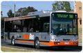
Buses are an important part of any transit network - especially in larger cities, in a "feeder" role linking together rail stations with catchment areas
-
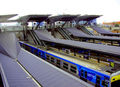
Trains and good interchanges are the backbone of a Public Transport network
-
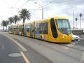
Trams, or "Light rail", can play an important intermediate role between trains and buses.


The role computer GIS tools play in transport planning, and Open Source software[edit | edit source]
The reason we think this is necessary and worthwhile to pursue is because:
- Many of the computer tools for analysing transport that came out of the developed world countries from the 1950s-60s onwards, especially the United States, focused on managing and planning transport with the assumption that the private car would be the clearly dominant mode of transport.
- But if we are to imagine and plan a future transport system that presents a genuine alternative to ongoing automobile-dominance, then we need tools that are closely oriented to the key ideas of an effective alternative:- using ideas such as Integrated multimodal network planning of public transport.
- A second aspect of this is that most of the tools used by professional transport planners and engineers has been developed and distributed as wikipedia:Proprietary software. The siginificant license costs and restrictions tend to restrict the use of these tools to large government departments and for-profit consultancies.
But if sustainable transportation is 'everybody's problem', shouldn't we try to reduce the barriers for different groups and people in society to understand their region's transport system, and work and advocate for possible improvements?
Our goal in this project is to investigate if Open Source software, as well as Open data formats such as GTFS, have advanced far enough to support a new approach to transport planning that is usable by small civil society organizations already advocating for better public transport planning in their city-regions. This could support a larger Transport modeling reform effort so that the design, structure and use of information systems used in transport planning better matches the goal of a more environmentally sustainable transport system.
Project Roadmap and Participants[edit | edit source]
One of the ways this project is being pursued is through an Action-Research project in Melbourne, Australia. This is a collaboration between User:PatSunter at the University of Melbourne, and several civil society organizations interested in future transport policy. For more background on this, see Melbourne Sustainable Transport Reform.
The key stages of this AR project are: (Last updated 2015-03-11 - for previous statuses see OSSTIP/WP Progress Archive)
Common Work Packages[edit | edit source]
| WP | Description | Status |
|---|---|---|
| OSSTIP/WP1 | Initial data gathering and familiarisation: Gathering, and familiarisation, with key data requirements and possibilities | Completed (c.f extensions) |
| OSSTIP/WP2 | Transport Informatics tools review: Assessment of key existing tools such as OpenTripPlanner given the needs of the project, see Open Source Transport Informatics tools | Completed (Bar better archiving of results in a VM etc) |
| OSSTIP/WP3 | Setup and design of Spatial Data Infrastructure to support project | Complete (need to add step of documenting VMs of system state) |
| OSSTIP/WP4 | Display of current Melbourne PT network in chosen tool (In practice, this will be quite closely integrated with previous WPs, especially WP2) | Complete |
| OSSTIP/WP5 | Workflow for conversion of GIS data into PT network schedule (Necessary as part of process so that a new network can be visualised) | Complete (do wish to better document and automate) |
| OSSTIP/WP6 | Setting up the capacity to modify and extend existing route lines from GTFS to create a new timetable | Complete (need to document properly). |
Then with each organisation, once we've developed some modifications to Melbourne's PT network (likely in an open source Desktop GIS such as Quantum GIS, will do several custom further WPs based on this common base.
Integrated into all of these will be Evaluation and Reflection and review of the tools' effectiveness given the project's goals, and also on the challenges and using Open source software in small civil society organizations.
While particular details of our case studies can only be published at the discretion and timing of the collaborating organizations - we are keen to share as much general source code and knowledge as possible.
BZE Work Packages[edit | edit source]
The first Action-Research partner for the project was Beyond Zero Emissions (BZE). We completed many work packages over the period of ~mid 2013 to Aug 2014. These were:
| WP | Description | Status |
|---|---|---|
| OSSTIP/WPBZE1 | Phase 1 Display of new BZE Network in chosen transport informatics platform. | Complete |
| OSSTIP/WPBZE2 | Evaluation of OSSTIP Tools Batch Trip Routing Capabilities for OD Datasets and to be refined decide, possibly using either the OSSTIP platform as a base for Travel zone based O-D analysis, such as in the Open Source Accessibility Toolkit project - or else supporting integrating results back in from other 3rd party tools being explored by BZE. | Complete |
| OSSTIP/WPBZE3 | Develop a web-based server to publicly communicate the benefits of BZE's new network, based on the OSSTIP platform. | Complete |
| OSSTIP/WPBZE4 | Convert a refined 2nd version of BZE's network into a GTFS timetable, and display in OSSTIP platform. | Complete |
Possible extensions discussed with BZE:
- Supporting a 'demand-driven local service'. Simplest way to simulate this would be to allow modification of walking speeds to much higher than normal.
PTUA Work Packages[edit | edit source]
The second Action-Research partner for the project was the Victorian Public Transport Users Association (PTUA). After several preliminary discussions and scoping we began the AR project work in August 2014, and the work packages we agreed (based on PTUA's "Every ten minutes to everywhere" campaign) and worked on from September 2014 through to March 2015 were:
| WP | Description | Status |
|---|---|---|
| OSSTIP/WPPTUA1 | Developing a timetable for a higher-frequency and expanded SmartBus network | Complete |
| OSSTIP/WPPTUA2 | Developing a timetable for an extended, higher-speed, higher-frequency tram network | Complete |
| OSSTIP/WPPTUA3 | Developing a timetable for an extended, higher-frequency train network | Complete |
| OSSTIP/WPPTUA4 | Integrating all proposed network changes into a multimodal OpenTripPlanner instance and generating analysis reports | In progress. |
Possible further WP in uploading the generated networks to the public OTP server.
Long-term goals for system[edit | edit source]
The goal is to work iteratively and collaboratively to develop an open source 'informatics' platform that supports understanding cities' existing transport systems, and as a decision-support tool that allows looking at options that suggest they will support a more sustainable transport system.
The core design goals of the system should be:
- Sustainable transport as a core design goal, not an add-on to modelling the status-quo. E.g. focus limited development resources around the most promising aspects of the system to improve sustainability of transport for large urban regions given current research.
- Incorporate current knowledge of best practices for planning public transport networks, such as Integrated Multimodal Network Planning.
- An informatics tool, that allows "scalable complexity" to support different types of users with different goals and data availabilities. For example, when data, time and resources are limited, support 'sketch planning' to visualise the impacts of adding public transport services, for example in the form of augmented Travel Time Maps. When the above resources are more available - then be able to call on more complex models and simulations, e.g. long-term predictions of integrated transport and land-use changes.
- Modularity, flexibilty, and update-ability.
- Be runnable on at least one Free and Open Source operating system, e.g. Linux
Such a platform would include not just software, but:
- Open Source software packages, and guides and howto's to put them together;
- Openly published data standards for key relevant aspects of the info system, e.g. public transport networks and timetables;
- Plans and protocols for the effective transfer of such data (e.g. web services);
- Known good sources of data, such as government providers with a track-record of good data curation practice;
- Documentation of suggested necessary computer hardware needed to run the platform, in either basic or advanced forms.
Initial designs will be linked to here as the ideas and project iterates. See the 'Next steps' section below for parts of this as they are written.
Current Work and Future Goals[edit | edit source]
For updates on work, see the Project blog.
As a project drawing on existing Open Source software, open standards such as GTFS, as well as Open/Collaborative data projects like OpenStreetMap - we welcome international collaboration, especially in sharing knowledge and expertise with using available Open Source GIS and transport analysis tools.
If others were interested in contributing:- I think a great thing would be to see public-transport oriented informatics platforms integrated with bike-oriented tools. This is possibly a very strong combination for a transport systems that includes both broad coverage, but low negative impact. Update 18/7/2013:- OpenTripPlanner already contains very significant cycling support now using its integration with OpenStreetMap data. See for example their New York bike routing system in support of the City Bikes scheme there.
Project Subpages[edit | edit source]
- Loading GTFS to a GIS database
- Notes on getting OpenTripPlanner Batch Analyst working
- OpenTripPlanner Issues
- Project blog
- Setup of OpenTripPlanner to display Melbourne PT network
- SimpleGTFSCreator
- WP1
- WP2
- WP3
- WP4
- WP5
- WP6
- WPBZE1
- WPBZE2
- WPBZE3
- WPBZE4
- WPPTUA1
- WPPTUA2
- WPPTUA3
- WPPTUA4
- WP Progress Archive
- visualise OD matrix in QGIS
Networked, Open Source Development Mode[edit | edit source]
The philosophy here would be to follow and the networked, distributed nature of Open Source development - and also the iterative approach of Agile software development. That is, in the short to medium term goals should be modest and match the resuources available, and leverage existing efforts as much as possible. Then as tools are field-tested and learning is involved and more stakeholders get interested - more ambitious goals can be attempted.
References and Inter-Wiki links[edit | edit source]
Project reference book[edit | edit source]
I have set up an Appropedia:Books functionality for the project, to gather together key pages and allow ready export to PDF/ODT:
- User:PatSunter/Books/OSSTIP-SustTransportReference - a longer book, which integrates reports on the OSSTIP project with relevant topic articles from the broader Appropedia project.
- User:PatSunter/Books/OSSTIP-ProjectUpdate - a shorter book, only containing OSSTIP specific pages about project goals, and progress on work packages etc.
Contact details[edit | edit source]
Interested Appropedia contributors:
- --PatSunter 22:14, 7 March 2013 (PST)
Talks, Media, and Academic Publications Related to the Project[edit | edit source]
About the technology in OSSTIP and general principles of FOSS tools for use in public decision-making[edit | edit source]
- PatSunter, 17 Sept 2013, Guest lecture at RMIT University, "Transit Accessibility focused GIS tools and their potential role in planning a more transit-focused metropolis"
- PatSunter, 21 Sept 2013, talk as part of 2013 Software Freedom Day (Melbourne), "The Importance of Free and Open Source Software for Public Decision-Making"
- PatSunter and Chris Watkins, 29 Oct 2013, presented a paper at the 2013 Prato Community Informatics Research Network (CIRN) annual conference, reflecting on the process of using Appropedia in this form of deliberative public engagement project. See our discussion on Vimeo, and the actual paper.
- See note about TransportCamp participation on 1st November in the following section.
Talks about Policy advocacy work for improved public transit, utilising some of these tools[edit | edit source]
- On 4 December 2013, Gerard Drew from Beyond Zero Emissions and PatSunter presented a talk to the Melbourne Metropolitan Transport Forum, on the subject
- "An Update on Beyond Zero Emissions' transport network reform proposal for Melbourne and underlying sustainable transport informatics software platform", which included a live demo using OSSTIP tools.
- On Sat 15 February 2014, Gerard Drew from Beyond Zero Emissions gave a talk at the 2014 Melbourne Sustainablve Living Festival, on the topic "Zero Carbon Public Transport Melbourne: Discover how zero emissions public transport is possible", which included demos of journey planning and analysis using an OpenTripPlanner server on both the 2013 and potential future transport networks. PatSunter provided technical assistance on the day.
- On 6 March 2014, PatSunter and two members of the Public Transport Not Traffic campaign in Melbourne (Dan Peade, and Anthony Aisenberg) were interviewed on RRR Radio Melbourne's Byte Into It show, about the use of ICTs in campaigns for improved public transport. Show summary and MP3 available here.
- On 1st of Nov 2014, PatSunter and BZE's Laurent Allieres attended and participated in the inaugural Australian TransportCamp un-conference in Melbourne. This included running a session on "designing a high-frequency intermodal network for greater Melbourne": see Patrick's presentation slides.
External Links and Related Efforts[edit | edit source]
- Some related ideas were developed and documented over at http://openplanningtools.org/ParticipatoryPlanning, during a collaboration with the Milwaukee Transit Riders Union, by Carl Fredlund and others.
- The National Center for Transit Research (NCTR) and the Florida Department of Transportation (FDOT) conducted a research project, "Enabling Cost-Effective Multimodal Trip Planners Through Open Transit Data". See the project's Final report.